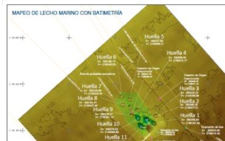
It is the site characterization performed before positioning a jack-up rig, laying a pipeline or cable, or installing structures: it identifies faults, shallow gas, obstructions and seabed hazards, and delivers the precision bathymetry that engineering design requires.
Multibeam echosounder (MBES), side scan sonar, sub-bottom profiler, marine magnetometer, DGNSS positioning with gyrocompass and motion reference unit (MRU), CTD sensor and an HTP 3000 USBL transceiver tracking down to 4,000 m.
Multibeam covers a full swath of seabed at high point density and produces engineering-grade 3D models; single-beam only yields profiles along lines. Pipeline routes, drill centers and FPSO moorings call for multibeam.
Yes: 2DHR multichannel seismic with air gun and streamer, resolving geological layers, potential hydrocarbon accumulations and sub-surface structure ahead of drilling.
Tell us about your scope, location and timeline. We respond within one business day.